Areas near the Sierra Nevada mountain range in the western United States will witness a very severe snowstorm in the coming days. Meteorologists are even talking about a historic storm, perhaps the strongest storm of the current winter. They expect huge amounts of snow to fall and the winds will also be strong. The National Weather Service warned area residents to stay indoors as much as possible. But where is this storm coming from? How much snow will it fall exactly?
Where did this snow storm come from?
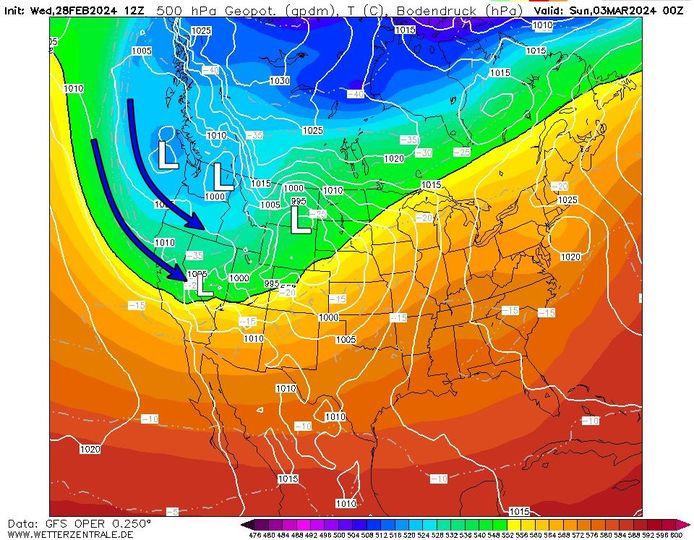
In the coming days, a large low pressure area will move across the ocean to the American mainland under the influence of a strong jet stream. Meanwhile, cold polar air will be supplied to the United States through Canada at the back of this low pressure area. The active disturbance associated with this low pressure area will collide with the Sierra Nevada via westerly airflow.
As a result, the area will witness heavy snowfall in the coming days. Snow amounts can increase significantly, especially at the top of the mountain range. As the air is forced to rise over the mountain, precipitation associated with the turbulence is further activated.
Read more below the picture

How much snow is expected exactly? What about the wind?
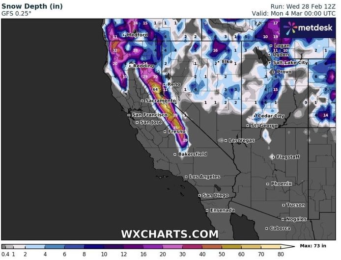
Snow amounts are particularly high on the leeward side of the Sierra Nevada as well as on the peaks. The largest amount of snow is expected to fall above 1,800 metres. Near Donner Pass, higher up in the mountain range, up to 1.5 to 2.5 meters of snow could fall between Thursday afternoon and Sunday morning. These are exceptional amounts of snow in a very short time.
Snowfall is expected to range between 1,200 and 1,500 meters and between 30 and 90 centimetres, and at lower altitudes between 750 and 1,200 metres, with snow levels rising to 15 to 30 centimetres. The higher you go, the colder it gets. For this reason, snowfall is mainly limited to mountainous areas and almost nothing falls in the lowlands. There is softer air there.
Read more below the picture

Not only will the blizzard bring snow to the mountains, but the storm will also be accompanied by strong wind gusts. According to recent weather model calculations, wind speeds are expected to reach 100 kilometers per hour or even a little more during the snowstorm. Maximum wind gusts are expected, especially on peaks and hills, as the winds are free to move there. This creates very bleak conditions.
Because of this combination of heavy snowfall and strong winds, the National Weather Service is warning of severe “blizzard” conditions. Continuous snowfall will also severely limit visibility in the area, making travel there inappropriate. The weather service recommends staying indoors as much as possible and not moving unless it is an emergency. It is best to postpone travel plans until after Sunday. Heavy snow and blizzard conditions will make it very difficult, if not impossible, to facilitate movement or travel. Therefore, there is a high probability that many roads will be closed because they will be covered in snow and visibility will be insufficient to allow safe travel. Those who want to venture out during the storm are advised to take a survival kit with them in case they become stranded and be sure to stay in the vehicle.
The climate winter is coming to an end: should we fear more rain this spring due to El Niño? (+)
New snow of 2 to 3 meters is expected in the Alps next weekend
Will the North Atlantic Gulf Stream really collapse due to climate change? “We are going to chat in Belgium” (+)
Free unlimited access to Showbytes? Which can!
Log in or create an account and never miss a thing from the stars.

“Lifelong food practitioner. Zombie geek. Explorer. Reader. Subtly charming gamer. Entrepreneur. Devoted analyst.”


More Stories
Revealing the ten countries that support Ukraine the most
Funny protest against mass tourism in Galician village
Kamala Harris has wind in her sails, but Trump can still win