Werner Dunk is an IT project manager and sailor. After a grueling journey through the Southern Ocean, he docked his Steel Two Master in New Zealand in 2018. In the Netherlands he published Karma van Staal, a book about a 200-day journey with various travelers. This year he took up the thread again and traveled to Cape Horn. via his blog karmavanstaal.nl He informs us.

Monday 16 October 2023 20.48 (CET)
I’m excited to leave, but with mixed feelings
In 12 days I fly to NZ. I’m ready for it, I’m afraid. Mixed feelings. I’m excited to get Karma ready for departure and start sailing again. At the same time, nerves run throughout my body. I’m not really afraid of distance, passing time, being cut off from the outside world, cold or waves. What scares me is losing Liane and the kids for so long. At the same time, it’s good to have those feelings. It’s only a concern if it’s different.
We have an amazing solution for cooling. Cool wool sweater from Rosenstein Volke. 100% recyclable and biodegradable. With the requisite merino wool layers and a good sail on deck, it kept us nice and warm. I’m almost ready.
Sunday 22 October 2023 08:15 (CET)
Are you really going to travel in a straight line like that?
For planning purposes, I have drawn the 42nd parallel. It is more comfortable than 49 or 46 degrees south. What we will do in practice remains to be seen. However, it may not be a straight line. The weather is very changeable for that. If there is a wind, we turn, if the wind is favorable, we turn again. In this way a familiar pendulum structure is created.
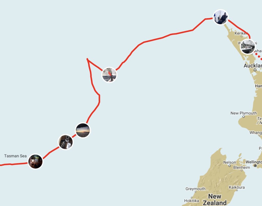
The dotted line on the map is the planned route. Almost in a straight line from New Zealand to Puerto Montt. Are we really going to travel like that? Of course not. In theory this is possible because there are no islands or other obstacles along the route. But in practice we will continue to look for good winds and somewhat comfortable conditions.
We travel east and always have to see how far north or south we want to go. Also north means higher temperature. Further south means colder and more extreme weather, stronger winds and higher tides. But we must go south, for the wind blows from the west, and we need it.
It is impossible to predict exactly how far south we go. We do this based on weather forecasts. Let’s discuss this with Coastal Navigator Root. For planning purposes, I have drawn the 42nd parallel. It is more comfortable than 49 or 46 degrees south. What we will do in practice remains to be seen.
However, it may not be a straight line. The weather is very changeable for that. If there is a wind, we turn, if the wind is favorable, we turn again. In this way a familiar pendulum structure is created.
From that pattern you can tell what the weather is like. For example, you see a sharp triangle on our sail across the Tasman Sea. There suddenly got wind force 6 straight from the front, which changed to wind force 10 a day later from a different angle. We do not like to see such triangles. Time will tell how exactly we travel.
In fact, the dotted line is not a straight line, but a complete curve. It is about 10,000 km. At the equator, the Earth’s circumference is about 40,000 km. So we’re going around a quarter of the world. Try using a waterproof marker to draw a straight line about a quarter of the football’s circumference. It is not possible.
The dotted line is not the shortest path. A narrow path leads further south towards the base of the ball. This saves 750 km. We would not opt for it because the chance of more extreme weather is very high. But if we do this and travel in as straight a line as possible, you won’t see it as a straight line on the map, but as a parabola (U-shape). The world is round and cannot be captured on a flat screen.
Werner Tounk
comments

“Introvert. Communicator. Tv fanatic. Typical coffee advocate. Proud music maven. Infuriatingly humble student.”





More Stories
Russian Tortoises: The Ideal Pet for Reptile Enthusiasts
Biden and Xi want to sit down one last time
The United States won gold in the team relay on the opening day of the mountain bike world championships